


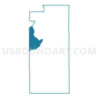
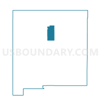
Santa Fe County Precinct 12, Santa Fe County, New Mexico
About
Outline

Summary
| Unique Area Identifier | 624110 |
| Name | Santa Fe County Precinct 12 |
| County | Santa Fe County |
| State | New Mexico |
| Area (square miles) | 94.01 |
| Land Area (square miles) | 94.00 |
| Water Area (square miles) | 0.01 |
| % of Land Area | 99.99 |
| % of Water Area | 0.01 |
| Latitude of the Internal Point | 35.63671520 |
| Longtitude of the Internal Point | -106.17713130 |
Maps

Graphs
Select a template below for downloading or customizing gragh for Santa Fe County Precinct 12, Santa Fe County, New Mexico


Neighbors
Neighoring Voting District (by Name) Neighboring Voting District on the Map
- Los Alamos County Precinct 1, Los Alamos County, NM
- Sandoval County Precinct 20, Sandoval County, NM
- Sandoval County Precinct 7, Sandoval County, NM
- Santa Fe County Precinct 14, Santa Fe County, NM
- Santa Fe County Precinct 62, Santa Fe County, NM
- Santa Fe County Precinct 72, Santa Fe County, NM
- Santa Fe County Precinct 80, Santa Fe County, NM
- Santa Fe County Precinct 82, Santa Fe County, NM
- Santa Fe County Precinct 86, Santa Fe County, NM
Top 10 Neighboring County Subdivision (by Population) Neighboring County Subdivision on the Map
- Santa Fe CCD, Santa Fe County, NM (85,892)
- Santa Fe South CCD, Santa Fe County, NM (39,958)
- Santo Domingo-San Felipe CCD, Sandoval County, NM (8,270)
- White Rock CCD, Los Alamos County, NM (5,737)
Top 10 Neighboring Place (by Population) Neighboring Place on the Map
Top 10 Neighboring Unified School District (by Population) Neighboring Unified School District on the Map
- Santa Fe Public Schools, NM (118,032)
- Bernalillo Public Schools, NM (24,342)
- Los Alamos Public Schools, NM (17,950)
- Pojoaque Valley Public Schools, NM (9,637)
- Jemez Valley Public Schools, NM (5,273)
Top 10 Neighboring State Legislative District Lower Chamber (by Population) Neighboring State Legislative District Lower Chamber on the Map
- State House District 45, NM (32,329)
- State House District 50, NM (31,808)
- State House District 46, NM (29,009)
- State House District 43, NM (27,235)
- State House District 65, NM (26,930)
Top 10 Neighboring State Legislative District Upper Chamber (by Population) Neighboring State Legislative District Upper Chamber on the Map
- State Senate District 22, NM (60,988)
- State Senate District 24, NM (50,233)
- State Senate District 39, NM (48,118)
Top 10 Neighboring 111th Congressional District (by Population) Neighboring 111th Congressional District on the Map
Top 10 Neighboring Census Tract (by Population) Neighboring Census Tract on the Map
- Census Tract 13.03, Santa Fe County, NM (6,888)
- Census Tract 5, Los Alamos County, NM (5,737)
- Census Tract 12.05, Santa Fe County, NM (5,290)
- Census Tract 103.04, Santa Fe County, NM (3,729)
- Census Tract 9402, Sandoval County, NM (3,566)
- Census Tract 109, Santa Fe County, NM (2,781)
- Census Tract 103.08, Santa Fe County, NM (2,349)
- Census Tract 110, Sandoval County, NM (1,963)
- Census Tract 13.01, Santa Fe County, NM (1,661)
- Census Tract 13.04, Santa Fe County, NM (902)